The European Space Agency (ESA) publicly released the first data products from its Meteosat Third Generation-Sounder (MTG-S) satellite during the European Space Conference in Brussels. These initial visuals demonstrate the mission's capability to map atmospheric temperature and humidity gradients from 36,000 km above Earth, directly supporting more precise weather predictions for the European continent and northern Africa.
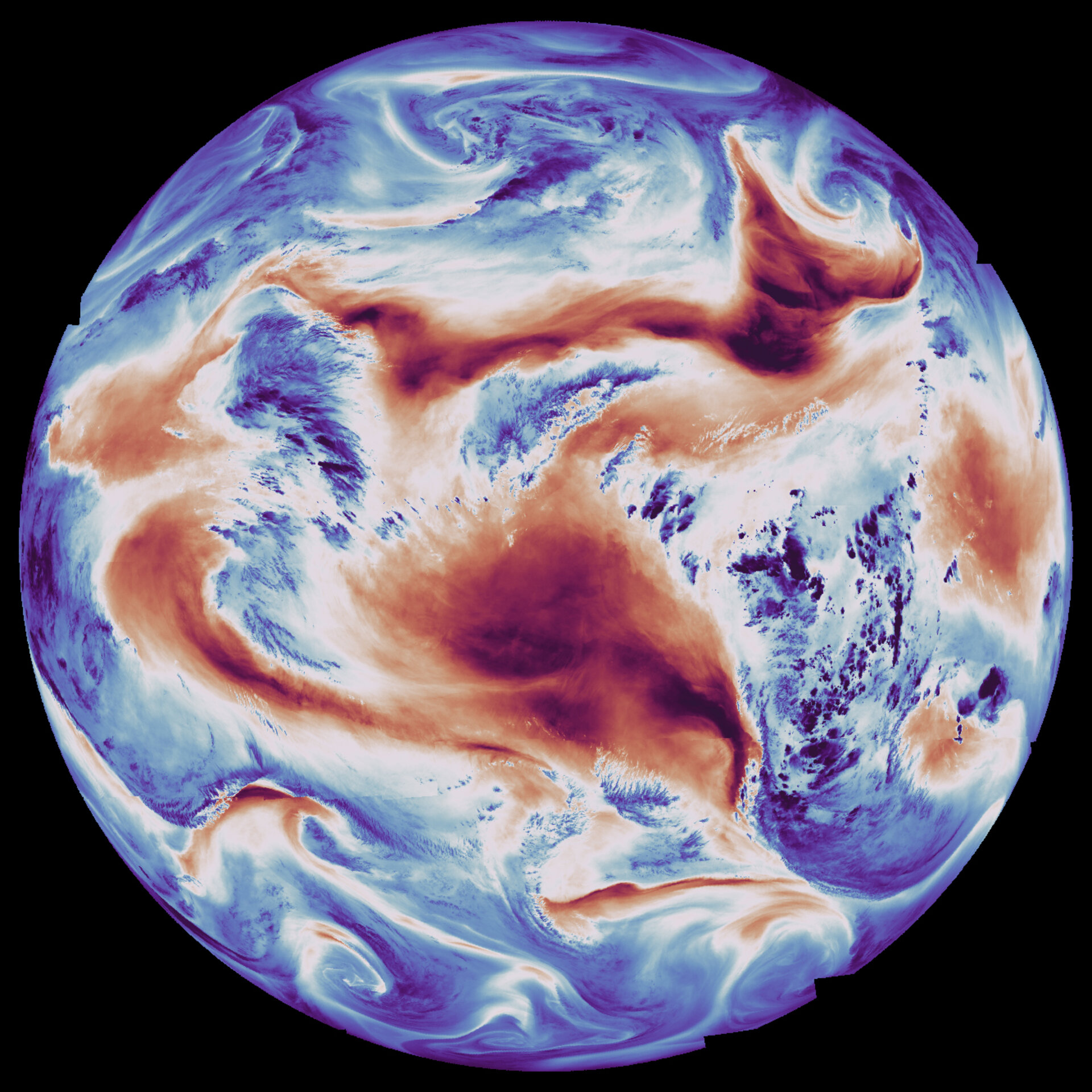
One set of images, derived from the Infrared Sounder’s long-wave infrared channel, displayed surface and cloud-top temperatures, where dark red indicated warmer landmasses like the African continent. The humidity map, utilizing a medium-wave infrared channel, differentiated atmospheric moisture levels, revealing very dry regions over the Sahara Desert and Middle East in dark red, contrasting with highly humid zones in deep blue.
ESA’s Director of Earth Observation Programmes, Simonetta Cheli, stated that the data is expected to fundamentally change how severe storms are forecast over Europe, benefiting both meteorological services and the public. The MTG-S carries the first European hyperspectral sounding instrument in geostationary orbit, capable of analyzing 1,700 infrared channels simultaneously.
Furthermore, the mission demonstrated its tracking capabilities by animating data that followed the eruption of Ethiopia's Hayli Gubbi volcano on November 23, 2025. This rapid observation sequence allowed for the timely monitoring of the evolving ash plume by correlating surface temperature changes with infrared signatures.
James Champion, ESA’s MTG Project Manager, noted that the satellite’s 15-year development culminates in the ability to vertically profile the entire Earth disk every 30 minutes for Europe. This high temporal resolution is particularly crucial for nowcasting, which focuses on predicting rapidly developing, short-term weather phenomena.
The MTG constellation currently operates the MTG-Imager (MTG-I) alongside the MTG-Sounder, with a second Imager planned for launch in 2026. Mission control and data dissemination are managed by Eumetsat, which integrates this new sounder data with existing cloud and lightning observations.
Ultimately, the instrument’s advanced interferometric techniques will enable the generation of three-dimensional atmospheric maps detailing temperature, humidity, and trace gases. This novel data perspective, according to Pieter Van den Braembussche, MTG System and Payload Manager, offers capabilities previously unavailable to European forecasters seeking early warnings for extreme events.
This mission represents a significant technological step for European Earth observation, developed through collaboration between ESA, Eumetsat, the European Commission, and numerous European industry partners, including prime contractor Thales Alenia Space.